Sunday, January 22, 2017

Off The Charts In Guyana - Into the Interior - Iwokrama

Lat and long at Iwokrama - that is 4 degrees latitude as in close to the equator

Kewl rainforest tree used to make local furniture


Jim with his new cabin mate

Iwokrama is basically like a one of our National Parks in the USA and more.   The rich biodiversity of Iwokrama makes it a nature draw for scientist, researchers and tourist.  It is considered on of the four remaining pristine forests.  The others are Amazon, Congo, Papua New Guinea.  The extent of the flora and fauna is staggering.  However, just like the rest of the globe, these populations are in trouble as well.  Thus the need for Iwokrama and the roll it plays. Plus it's a really kewl place!
Our room


Shared - 2 heads and 2 showers

As I mentioned before, the initial lodging at the Iwokrama River Lodge was quite expensive for our cruising budgets, however upon further research, we discovered that they have “student” and “researcher” housing and since they didn’t have any students or researchers at the time, we could stay in those for $25US and $50US per night.  Woo hoo.  This housing was tucked back alongside the staff housing and perfect for our little circus.  They weren’t sure of the breakdown of our group (couples or singles) so they assigned us 4 four rooms for the 7 of us to use.  There is also dorm style housing.  Mark our driver stayed in his hammock under the covered walkway of staff housing just across from us.  The rooms were simple but clean and we shared 2 showers and 2 heads in a common area. 
Activity center

Roof is built for rainwater collection

Inside the activity center

Inside the activity center

The main activity center was a beautiful hexagon structure set back from the river.  The roof was designed so the center was concave and thus collected water for the cisterns.  Three meals a day are available at the activity center.  The menu is set.  After dinner, the head guide met with us to discuss the excursion options.  All trips inside Iwokrama require a guide.  There was one other group on site, a birding group from Norway.  They were staying in the fancy River Lodge cabins.  We made our choices for trips and then spent the rest of the evening wandering around the grounds and then having an evening night cap on the walkway in front of our rooms.
Covered walkway outside our rooms
Kitchen crew - yummy meals from them

Forestry major Addit and head guide Michael

The next morning we were up at 5am and over to the activity lodge for a quick cup of coffee/tea.  Our guide met us at 5:45 am and soon we headed out on a walk through the surrounding rain forest.  Right off the bat, he spotted several bright colored macaws and toucans.  Before we even left the lawn of the River Lodge we also spotted an agutti under a wax apple tree nibbling on the fallen fruit.  Our guide was very knowledgeable, answering all of our questions.  His ability to hear and then spot various birds was amazing.  We also learned about all the various flora and fauna as well as their uses in ancient times and even now.  Bush medicine is still alive and well in the Caribbean and Guyana is no exception.  And before you discount that, please remember that most modern medicines have their roots in bush medicine.  Note - There are also trees and plants that are used for local furniture making, and in ancient times signaling others as well as tribal warfare (poison).
This tree is good for fighting diabetes

Strangler tree helps with inflammation thus I decided to crew on it directly - just kidding
I forget the name but this tree helps fight malaria

When we met with the head guide (Michael) the night before, he informed us that a special bird of some sort nicknamed the cow bird was recently spotted and that perhaps we might see.  According to him, it was one of the main birds the Norwegian birding group came to see, aka a big deal.  I am sorry but I forget the real name but the nickname was appropriate as we soon found out as it truly sounds like a cow mooing.  Our guide spotted the cow bird first the then we all waited quietly……yes, I was astonished our little circus could actually be quiet, but we were…..then we heard it……MOOOOOOoooo.  OMG just like a cow.  And before you laugh and ask me if I am sure it wasn’t just really a cow….yes, it was a bid.  We heard it several times.  In fact, as we wondered through the rainforest, I believe we heard two separate cow birds.  Note-   The poor Norwegian birding group got shut out on the cow bird, not on sighting or sound.  However, NOT our fault.  Surprisingly, our crazy little circus was able to stay pretty darn quiet during our walk.  Yeah, I know.....I had my doubts about our ability to be quiet but we pulled it off.     
Our guide for the early morning walk

"Where?  I don't see it."  "There"  "Ah ha"  "Ooo, look over there at that weird bug"  "Where?"

The walk was supposed to take 45 mins but we were in no hurry and neither was our guide so we didn’t get back to the lodge until 7:15 for breakfast.  The buffet was a plentiful offering of Guyanese food – I forget specifically but there was bake (fried bread), saltfish, plantains, stewed pumpkin and green beans I think and fruit along with local juice from fruits grown on the grounds.  YUM!  We spent the rest of the day wondering around the grounds, napping, checking out the macaws, toucans, and other birds, looking for the local caiman (alligator) named Sanka and just limin'.  A few of us walked back down to the ferry crossing.  I wanted to see if I could find the big cat paw prints I had seen in the mud the night before.  However, no luck.  The tracks had been washed away.  Stuart, Paul and Ian showed up that evening after dinner.  They had their own special tales of The Red Road.

Chow line - yummy food
Local dishes - pepper pot, pumpkin and beans, plantins and breadfruit salad - yum

We didn’t spot Sanka the first couple of times we went down to the river but one of the guides suggested we try again at sunset.  Great!   What better way to pass happy hour than looking for caiman while drinking beer……”Hold my beer and watch this” quickly comes to mind, doesn’t it?  As if on queue, Sanka showed up at the dock.  She is HUGE.  At least 12 ft and probably closer to 14ft.  She cruised around the dock area, often times very close to shore, coming in between the small river pirogues.  Eventually she snuggled up under the dock.  We were all a bit surprised to see that.  Rich said “Holy crap.  I know the sign says “No Swimming” and that is obvious but quite honestly, earlier today when it was hot I came down here and I was this close to taking my Keens off and dangling my feet in the river to cool off!  I thought, dangling feet isn’t swimming.  Good thing I didn’t.  Sanka was probably under the dock!”  Yep, our little circus always seems to be inches away from become a You Tube video of stupid things people do. 
Dick was not about to be part of a You Tube video of stupid things people do

"He's right there.  Hold my beer and watch this"  Just kidding


You Tube video waiting to happen - People vs camin

Sanka - big girl

Sanka very close to shore

The next morning we wondered around the grounds and surrounding area some more.  The head guide said we should not go out on our own without a guide.  When we asked another guide about a specific trail, she said it would be ok.  Cruiser Kathy said “How lost can we really get on that trial as it is boxed in by the resort, river and two roads!”  True enough.  However, when we came back out on the road we entered the trail from, we saw the continuation of that trail on the other side of the road…..not boxed in…… ”Let’s just go for a bit on this and see where it goes.”  It was ok for a bit but then we came to a fork in the path and then another and then another.  Rot-row……And now we are headed down the path to becoming  a You Tube video called Stupid American’s get lost in the rainforest of Guyana after being told not to go without a guide.  However, in the distance we could hear the Iwokrama River Lodge generator so we just kept moving in that direction.  Jim marked each of the forks in the path so we would know which we came from in case we had to double back.  Finally we came out in back of the River Lodge grounds.  Whew!
Tom got the point.....bahahhaah - look closely...sharp points on the bark

Weird.....somethings hanging down????
Curly branches

Curly branches

Note - Macaws and toucans....It is really hard to get a good pic of these bird as they hang out near the tops of the trees.  Plus we only have a little point and shoot camera (which we are very lucky to have thanks to our friend Terry)  vs a proper birding camera.  However, it wasn't too hard to find them as they are really loud.  Iwokrama has a large population of both birds.  One morning there were 8-10 toucans in one tree alone.  Very kewl!  There are tons of other birds as well.  I know, I know, tons probably isn't a proper birding term but there are!
Macaw -click and zoom in for a better look

Macaw - click and zoom in for a better look

Below are some additional random pics from Iwokrama including information posters.  Read if you want, skip if you don't want to.

View of Essequibo River from Iwokrama activity center

Beauty in hiding - Tom wanted to take her out SO badly


Poster about the bats of Iwokrama - yay bats

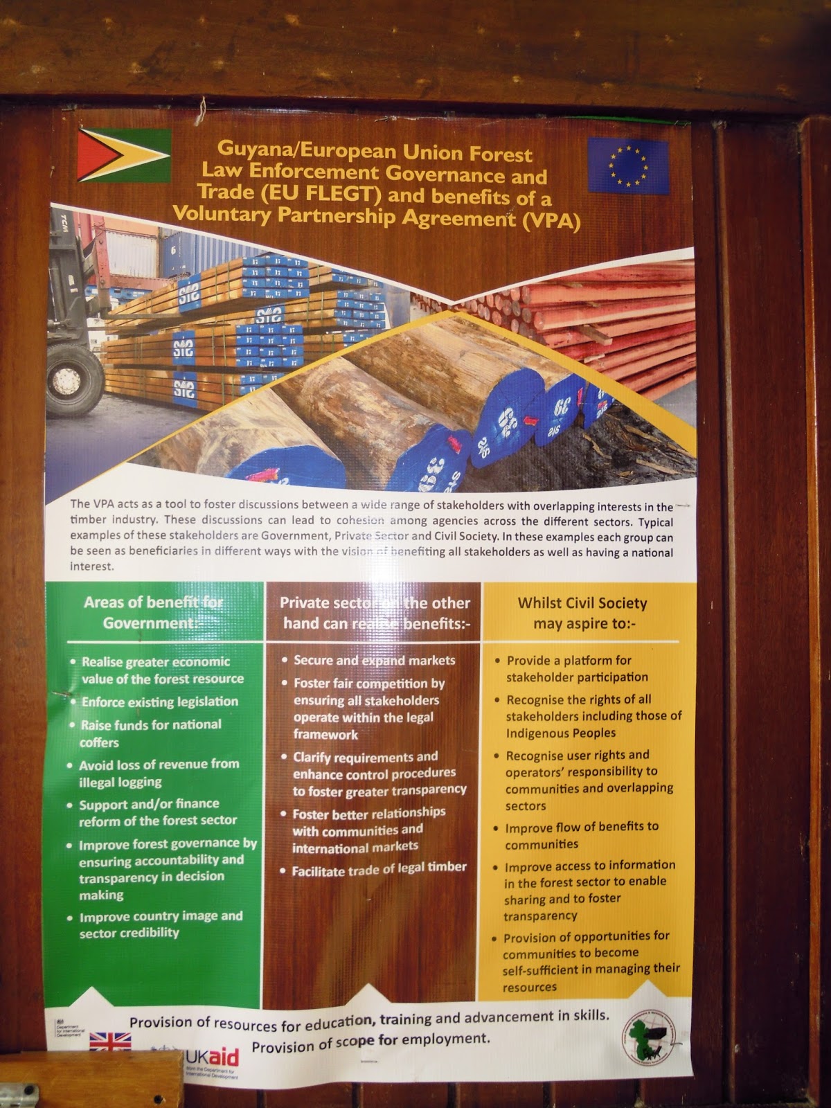
Poster about Guyana / EU timber agreement


Poster about Guyana / Norway Carbon Credits


Poster on impact of timber harvesting


Friday, January 20, 2017

Off The Charts In Guyana - Trip into the Interior - The Red Road

The Red Road
To get to Iwokrama you travel over land on the main road that runs from Georgetown to Lethem, which is on the boarder between Guyana and Brazil.  This is THE main road running north from the capital through the country to the southwest boarder.  The main thoroughfare.  Think of our interstate system in the USA.  This main road would be the equivalent to I-70 or I-80 or I-95 or I-35 - major roads that run through many states. Major interstate roads that many people use to transport themselves as well as goods here and there around the USA.  This MAIN road in Guyana is their equivalent in terms of importance and use.  So you get the idea, right?
The Red Road potholes filled with rainwater

We learned that this road is also called The Red Road.  That is because the bulk of this road is red dirt.  DIRT.  Did you hear that?  The main transportation artery is dirt!  Actually, half of the time it's red mud!  This road made such an impression on our circus that I had to do this separate blog posting to share with you.
Our ride
Our driver Mark picked us up at the airport in Georgetown.  The vehicle was a brand new mini van with air conditioning and tricked out with graphics and a name (Brandon, after his only son).  Comfy!  We shoved our backpacks in the back and piled in.  One item of special note was the three jerry jugs of petrol/gas on the roof rack along with a beefy spare tire.  Hum?  FYI - Mark has two girls as well.  I asked him if he had anything named after them.  It turns out that he has two cars and each is named after a daughter - good for Mark!
Note the jerry jugs of extra fuel

Brandon

We made a few quick stops for snacks and beverages for our cruising circus and a ferry ticket for the K Crossing.  We couldn't mess about too long as Mark reminded us that we really needed to get going so we could make the K Crossing.
K Crossing

K Crossing

The K Crossing is Kurupukari Ferry Crossing, hence forth known as the K Crossing because that is just too hard to say let alone spell.  It is where The Red Road crosses the Essequibo River.  It is approximately 200 miles from Georgetown.  The ferry runs from 6 am to 18:00 (6pm).  The last crossing is at 18:00 (6pm).  If you don't make that crossing, then you are forced to stay on the north side of the river and wait until morning to cross.  The fun twist is that there is no place to stay on the north side.  "You MUST make the last ferry crossing or you will have to sleep in your van or in hammocks in the trees." I was told on the phone by more than one local when we started making all the arrangements.  Sleeping the van or hammocks by the side of the road was not something our circus wanted to do!  FYI - regular maxi taxi busses make this trip daily.  They leave from Georgetown at 16:00 (4pm) and drive all night to make the first crossing the next morning.  This allows the passengers nearly a full day in Georgetown to shop, go to appointments or whatever.  This is also one of the reasons we decided against using that as our mode of transportation.
The Red Road - loaded down maxi taxi headed the other way

Several miles outside of Georgetown the pavement ran out and the Red Road officially started.  The road was a couple of lanes wide here (let's say 4) but even wider because everyone was driving on the shoulders.  The part of the road that makes up the main lanes was filled with deep, deep potholes, so everyone of course drives on the shoulder to avoid them - makes sense!  However, they have been doing it long enough that now the shoulder has it's own potholes.  This reduced our speed significantly.  Mark expertly wove the van to this side and then that of the various potholes, often driving clear over to the other side of the road (into oncoming traffic - albeit slow traffic) to avoid a nasty serious of potholes.  It was really amazing.  The Red Road wasn't all potholes, there were stretches that were realitively pothole free.....overall, probably 50% with potholes.
Fuel truck

Logging truck

Soon we began to see the huge fuel transport trucks along the Red Road.  One was broken down.  The driver was sitting in the shade of the truck next to a fuel pump, smoking a cigarette.  Mark informed us that all vehicles traveling The Red Road have spares.  By spares, I don't mean just a spare tire (tyre if your English) and fuel but SPARES;  fuel pump, altenator, hoses, engine oil, transmission oil, extra gear boxes and of course tyres and petrol.  There is no Triple A or Car Club to the rescue if you break down.  Thus all the drivers are also mechanics as well.  They have to be able to fix their own vehicle.
We passed fuel trucks, logging trucks, supply trucks, other maxi taxi vans, and a few regular cars.  Interestingly, many of the regular cars were jacked up slightly.  Not in a tricked out, cruisin' the bouvard kind of way, but in a practical way so when they do have to go through a pothole, they don't bottom completely out and mess up their frame and undercarrage.  We noticed that many of the fuel, logging, and supply trucks seemed to have a spare rider outside, up-top, in back of the roof of the cab.  It didn't seem to be for security but more catching a ride.  Hum?
Local car 

I mentioned above, that the local Maxi Taxi busses leave Georgetown and travel overnight.  At the Brazilian boarder town of Letham, they leave early morning or even pre-dawn heading back into Georgetown.  When we would pass one of these going the other way towards Georgetown, both Maxi's would stop to visit briefly.  This wasn't "Hi, how's the family?" but rather "How's the road ahead?  Is it passable?  How is the such and such bridge?"  Serious stuff.  Of course these converstations were kept short because we had to stay on schedule to make the K Crossing.
Stopping to exchange information about road conditions - note the freeze on top for storage

The regular Maxi Taxi busses were an interesting sight.  They were stuffed to the roof with people and supplies.  People travel from the interior into Georgetown to resupply for the month and then they travel home again.  All that stuff has to go with them.  As I have said before.....how full is your car after a visit to Costco Warehouse Club?  I assumed the busses would carry fewer people when the riders have more stuff.  I was wrong.  They carry the normal passenger load and just cram the stuff in anywhere they can, to the ceiling inside.  Then the roof racks are piled high.  We even saw one maxi taxi where two or three guys were riding on the roof rack.  I suspect they were only catching a ride a short distance down the road but I could be wrong.  They might be going all the way like that.  Given how cram-packed the maxi was inside, I can't say I blame them.  
Maxi taxi headed the other way

We passed through Linden, which is a fairly ok sized town.  Interestingly, it lays 50 kilometers straight east of our anchorage at Baganara Resort but as I mentioned before, there was no way to get from Baganara to Linden.  We also passed through a very small villages but only a few.  The guidebook was right, the bulk of the population of Guyana lives on the coast and along the major rivers.
Brush in the road

As we traveled south, this MAIN highway narrowed down.  Soon it was only a two lane road.  Further south, it became a narrow two land road.  And then a one lane road at times.  Again.....this is the major north/south road in Guyana and it wasn't more than a dirt road you might travel off county road #15 to see your farm friends or say to get to your holiday ski cabin in the woods.
One of the many bridges we went over

We passed over many small creeks and rivers.  The bridges over these were made up of huge timber planks that were 10" to 12" inches thick, 12" wide and 30 ft long.  There were 6 to 8 laid down to make up the bridge.  Just laid down side by side, not nailed together in some sort of structured bridge.  Of course it was one lane.  On one or both sides of the creek/river there was usally extra planks in case the ones making up the bridge got cracked, broken or dislodged.  I assume those were for the road crews to replace as I don't know how we would have done it ourselves.  However, many of the vehicles of the The Red Road have beefy electric winches on the front for towing so perhaps they do switch out broken bridge planks.  I guess if a broken bridge plank is keeping you from continuing along, you do whatever you have to do.  Those winches get a regular workout during the rainy season when drivers often have to winch each other out of huge, mud filled potholes.  We did see one road crew running a grader but I suspect these crews are few and far between.  Self-sufficeny is vital on The Red Road.
Pitstop

The Snackette

A little over mid-way, we stopped at Nowhere Land - Peter and Ruth's Snackette to refuel, stretch our legs, get a snack and hit the head.  It was a proper filling station like those in the USA.  Mark had a quick lunch, the rest of us a snack.
Mabura check point

Rich and Tom waiting to get their passports checked

Another stop was at Mabura, which is an official border check point despite the fact that it is 331 kilometer from the actual border.  We never did get a clear answer as to why it is SO far from the border.  I think it is just a weighpoint to re-check people coming and going because the borders are primarily rainforest and rivers and thus not so secure. Mark had to take the manafest (crew list) into the officials.  We then had to go in with our passports.  We were obviously tourist so it was easy-peasey for us and soon we were back on the bus.
The Red Road behind the side - see how it narrows down

We drove on and on, passing fewer and fewer vehicles as the road narrowed down to a back country road size.  I was in the second row of seats but I could see Mark kept checking his watch.  "Oh no" I thought.  "Are we going to make the K Crossing?"   It was 17:00 (5pm) and he was checking his watch every 5 mins or so.  Ugh!  There was really no way to speed up.  The condition of the road dictates the speed you can travel on The Red Road.  I started to worry.  I looked around for any little village, or grouping of houses or shacks that could perhaps put up our weird little circus for the night should we miss the crossing.  There wasn't really anything.  As it turns out, Mark was just trying to freak out Dick who was in the front seat and had been teasting and joking with Mark most of the day.  We arrived at the K Crossing at 17:30 for the 18:00 crossing.  Whew!
WHEW - we made it in time for the 18:00 crossing


The K Crossing ferry


K Crossing ferry pilot house

The river crossing is a pretty short distance.  The ferry itself is essentially a floating barge with a diesel engine and a tiny pilot house at the back.  The ferry arrived on our side and a hugh lumber truck off loaded.  It struggled to get up the muddy ramp.  A small fuel truck arrived and loaded onto the ferry first.  Then Mark backed the van on.  All vehicles are backed onto the ferry for easy offloading on the other side.  We all walk on and rode across outside the van.  The crossing took 10 mins max.  We loaded back into the van for the short 5 mins ride to our final destination Iwokrama.  Special Note -  When we were on the other side of the ferry crossing waiting for Mark to offload the van, I was wandering around just off to the side of the muddy ramp.  I noticed some large cat prints.  Large!  Later I told a guide at Iwokrama what I saw, he said it was more than likely a jaguar or puma print. WOW!
Lumber truck just off the K Crossing ferry

Mark backing onto the K Crossing ferry

So that was our journey into the interior via The Red Road.  I know it made a last impression on Tom and me.  At the very least it was interesting.  Our trip into Iwokrama took 7 1/2 hours.  Our trip out took 8 hours.  It rained a bit before we departed on the trip out, so it took slightly longer.  Note -  Mark said once or twice during the rainy season, parts of The Red Road are simply impassable.  Guyana has two rainy seasons a year.  I guess it is sort of like a blizzard shutting down I-70.  Additionally, after spending time in the interior at Iwokrama with the guides, we were able to spot more wildlife as well as the logging access roads along The Red Road.
Refueling on the drive back to Georgetown

Off The Charts In Guyana - Trip into the Interior - The Beginning

The "Circus" for this excursion
Tom and I were interested in seeing some of the true "interior" or "bush" of Guyana that locals kept referring to.  We mentioned it to the others in the group and soon we had enough for a proper "circus".  Ha!  Seven total.  Plus Baganara owner Stuart, manager Paul and their friend Ian from Canada would join us in their own vehicle.
Planning session
I think I have mentioned before that Guyana hasn't really developed their tourism trade to the extent that other countries have.  While there are a few tour operators, their excursion offerings were too pricey for budget conscious circus, so we set about planning the trip ourselves.  NOT an easy task as there were many components - various segments of transportation, lodging, excursions, food/beverage, etc...many phone calls
Iwokrama main building

Fancy cabins

Our destination was Iwokrama Interational Centre for Rainforest Conservation and Development, a 1 million acre research project set in the pristine Iwokrama Forest.  "It's a living laboratory bubbling with a staggering number of flora and fauna" according to the Brandt guidebook.  It is 320 kilometers from Georgetown.  "Iwokrama's main business initiatives - tourism, timber, training and intellectual property and services".....Weird as this is going to sound, 50% of the land is designated as the Sustainable Utilisation Area, or money-generating pursuits, and the other 50% is the Wilderness Preserve.  Yes, timber (logging) and conservation side by side.  Guyana's tourism and especially eco-tourism does not bring in enough money alone to support Iwokrama.  "Reduced Impact Logging" is paying the bills.  They hope to "show that timber can be harvested in a protected area while demonstrating enviromental sustainability and social sensitivity."  The old guide book I had mentioned hammock camping. Bingo - we already had hammocks and are of course experts (NOT) from our camping trip to Rockstone Fishing Camp.  However, after a few calls, we learned the hammock camping has given way to cabins.  The first lodging options were too expensive.  But, I discovered from Iwokrama directly that they also have student and research housing.  Bingo!  Perfect for our budgets.  AND.....no hammocks needed.  We did take them just in case we didn't make the K Crossing - but more later on that.
Student, research and staff housing - "Circus" housing

Our first task was to get from Baganara Resort to Georgetown.  Despite the fact that the MAIN road to Iwokram was only 50 or so kilometers southeast of our anchorage, we were forced to travel north into the capital of Georgetown.  I tried and tried but there was simply (or otherwise) no way for us to get over to the MAIN road.  This meant we were looking at a river pirogue into Bartica, a river pirogue down to Parika and a maxi taxi from Parika to Georgetown and probably a hotel stay.  Instead, we opted to take one of the tri-weekly commuter flights from Baganara Resort to Georgetown - 35 mins flying time beats hours.  FYI -   We looked at flying into the interior directly but the cost was too high.
Gate agent on the left
SIDESTORY - When we boarded the plane, I had the unique opportunity of sitting next to a local guy from Bartica that happened to also be the only passenger that day to check his gun with the pilot as required by law!  The gate agent - by gate agent I mean one of the resort guys in shorts and flip flops who ask all of us waiting in the gate area - by gate area I mean a concrete lean-to at the end of a runway- "Does anyone have any weapons?  Knives, cutlasses and such?"  Most of our circus had small knives/leathermans.  "You cannot have them on you or in your carryon."  Although we ended up packed into the plane like sardines to the extent we could barely move our arms enough to pull a leatherman as a weapon and how on earth would we charge hunched over or crawling up the 24" aisle to the pilot for a takeover of some sort but.....okay, rules are rules.  "Can we just put them in our checked luggage (backpacks) now?"  "Sure".  So that is what we did.  I didn't see it but apparently my soon to be seatmate lifted his shirt to show the pistol at his waist.  When we went to board, he took it out of his waistband, removed the ammunition cartridge and gave the pistol to the pilot, who simply put it into the side pocket in his door on the airplane.....much like the side pocket in the door of an automobile.  This is a small commuter plane so you can imagine that the noise level from the engine is quite a bit higher than a big commercial jet.  This made talking hard.  However, I was DYING to ask my seatmate about the gun.  Come on.....you knew I would, right?  Instead we talked a little bit about the terrain we were flying over and other nicies.  "Yes, the rain forest does look like broccoli when you are flying over it."  "Yes, those are rice fields.  Guyana grows quite a bit of rice"  "Yes, I am from Guyana."  and so on.  He said he was on a weekly "shopping trip" from Bartica to Georgetown.  Hum?  I noticed in the gate area/concrete lean to, that he didn't have any luggage.  His only carry on was a laptop bag that was too light and floppy to have a laptop in it and a small lunch size soft cooler.  I offered to hold one or both as he was getting into his seat but he quickly declined, guarding them both closely.  "Weekly shopping trip."  Hum?  He said he was flying back on the afternoon flight.  Hum?  After we landed and headed for our transportation, the other members of our circus wanted to know what was up with my gun carrying seatmate.  We all decided that he must have been transporting gold and/or diamonds down to Georgetown and perhaps then order supplies and equipment for a mining camp as the "shopping" part.
Gate area

Anyway, we arrived in Georgetown, grabbed our backpacks and headed out to find our driver Mark.
Rain forest looks like broccoli from a plane
Up next - The Red Road